Open Street Integration Guide
This guide explains how to enable OpenStreetMap Nominatim (aka “OpenStreet”) geocoding for facilities in Salesforce using the provided Apex classes and Visualforce page.
Scope: Single‑record geocoding for FreightTM__Facility__c. No batch geocoding is performed.
The OpenStreet integration follows a simple routing flow:
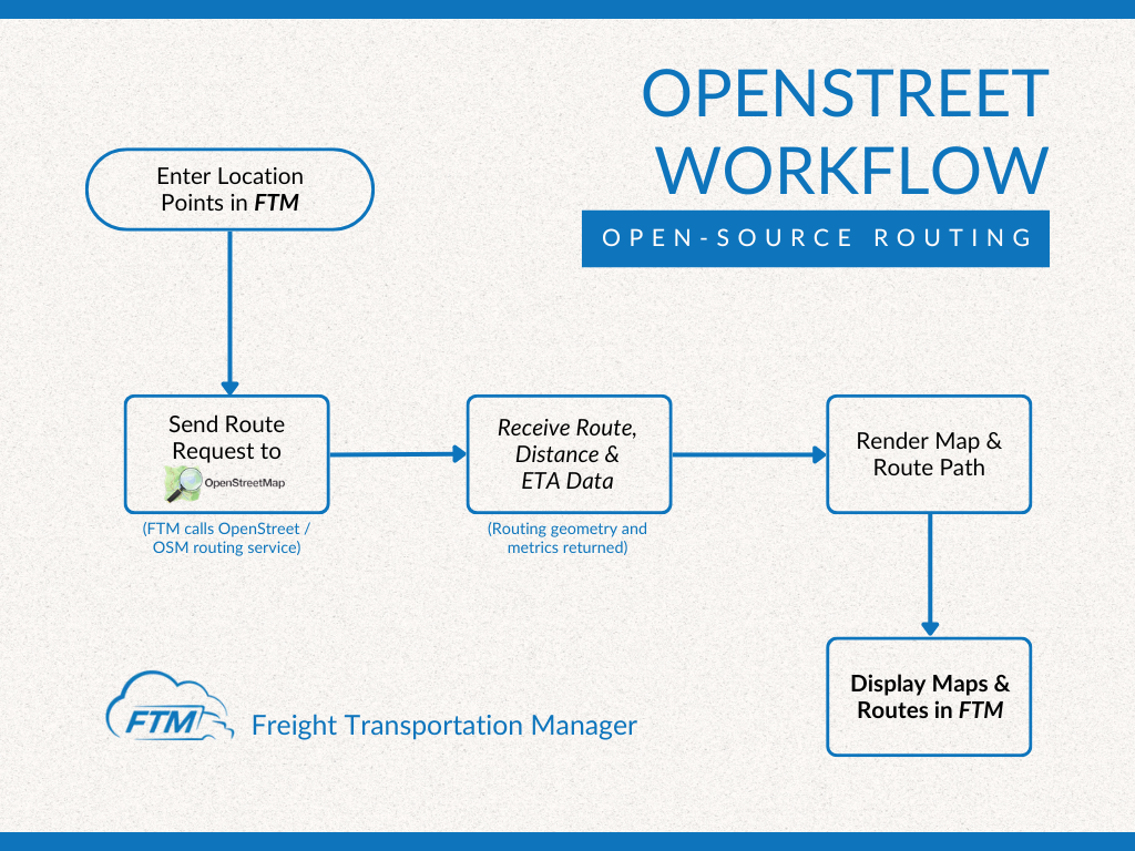
- Locations are entered in FTM
- FTM sends a routing request
- Route, distance, and ETA are returned
- Maps and routes are displayed inside FTM
Overview
The integration calls Nominatim Search API to convert a facility’s address into latitude and longitude, then writes the values to Coordinates__Latitude__s and Coordinates__Longitude__s. If a match isn’t found, the system emails country‑specific contacts (from Country_Email_Mapping__mdt) to request a manual fix.
OpenStreet Usage
Where you’ll use OpenStreet in FTM
You’ll interact with OpenStreet anywhere routing or distance is required, including:
- Shipment creation
- Load planning
- Route visualization views
- Map-enabled shipment screens
There is no separate OpenStreet login or external screen.
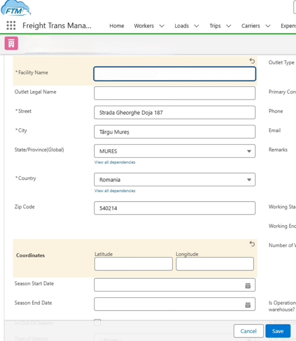
A) Enter shipment locations
Open a shipment in FTM and enter:
- Origin
- Destination
- Optional intermediate stops
These location points are the input used for routing.
B) Generate route and distance
Once locations are saved, FTM automatically requests routing data using OpenStreet.
You don’t need to click an external link or open another system.
C) Review route details
FTM displays the returned routing data, including:
- Total distance
- Estimated travel time (ETA)
- Route geometry
This helps planners quickly validate trip feasibility.
D) View route on the map
The calculated route is rendered directly inside FTM’s map view.
You can visually confirm:
- The selected route path
- Stop order
- Overall trip flow
Notes & limitations
- OpenStreet provides general routing, not carrier-specific restrictions
- It does not include booking, dispatch, or compliance logic
- Routing results depend on available open-source map data
For truck-specific routing logic, a different routing provider may be used.
Key components
- Apex: GeocodingService (core logic) and GeocodingServiceExtension (VF controller extension)
- Visualforce page: Triggers geocoding on page load and redirects back when done
- Custom metadata: Country_Email_Mapping__mdt with an Email_List__c per country
What This Integration Does
- Builds a single search query from Street, City, State/Province, Zip, Country
- Sends an HTTP GET request to Nominatim (/search?format=json&limit=1&addressdetails=1)
- Parses the first result and updates the facility’s coordinate fields
- If no result: sends an alert email to a configured list for that facility’s country
- Displays status messages in the page and auto‑redirects back to the Facility record on success
Setup Requirements
- Allow the external callout
- Remote Site Settings (quick & simple):
- Name: Nominatim_OSM
- URL: https://nominatim.openstreetmap.org
- Or Named Credential (recommended):
- Named Credential URL: https://nominatim.openstreetmap.org
- No auth needed; use it for cleaner code & admin control.
- Remote Site Settings (quick & simple):
- User-Agent header
- In GeocodingService.getGeolocation, set a clear User‑Agent that identifies your app and contact:
- Example: FTM/1.0 (contact: [email protected])
- In GeocodingService.getGeolocation, set a clear User‑Agent that identifies your app and contact:
- Permissions
- Users need read/write access to FreightTM__Facility__c and the coordinate fields
- Apex Class Access for both classes
- Visualforce page access
- Email Deliverability set to All email (for alert emails)
- Custom Metadata — Alert recipients
- Create Country_Email_Mapping__mdt records
- Master Label / Developer Name: match the Country stored on the Facility
- Email_List__c: comma/semicolon‑separated list of recipient emails
- Create Country_Email_Mapping__mdt records
- Page Layout Button
- Add a button or quick action to open the VF page (e.g., Update Geolocation) on Facility.
- Attribution
- Ensure your UI (e.g., help text or a footer in the VF page) includes proper OpenStreetMap attribution per licensing.
How It Works
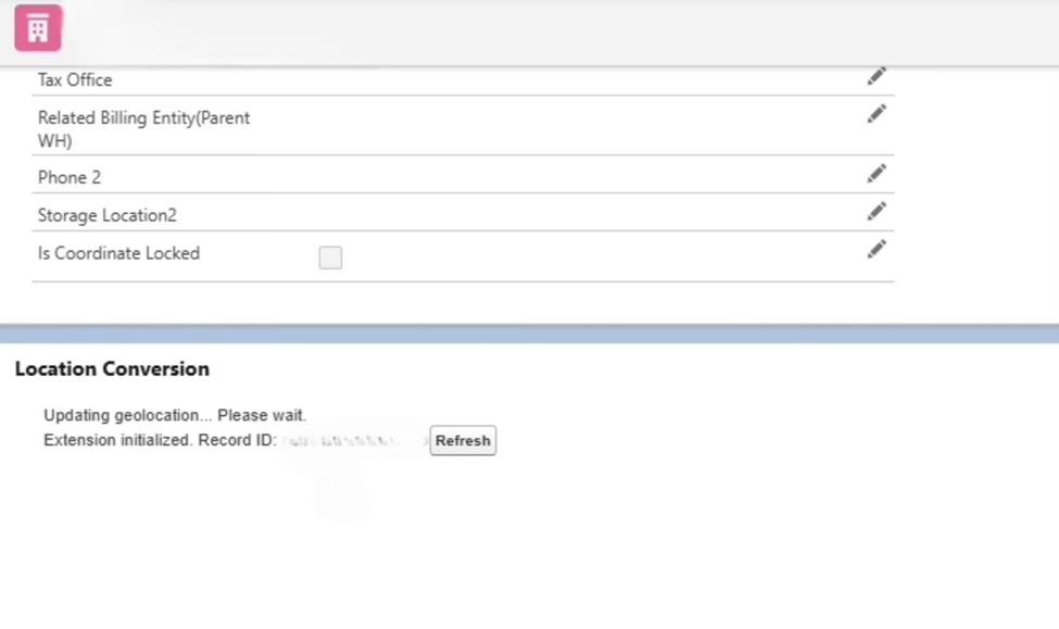
- User opens the Update Geolocation VF page from a Facility record.
- On page load, GeocodingServiceExtension.init() calls GeocodingService.processFacilitiesGeolocation(recordId).
- processFacilitiesGeolocation reads the facility address, calls getGeolocation(…) and receives a JSON array.
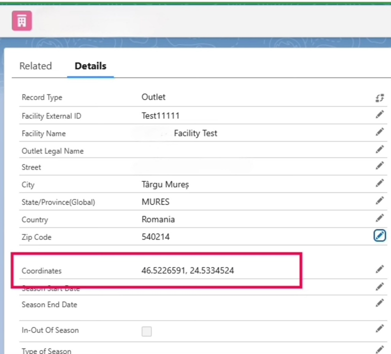
- If a result exists, the code writes:
- Coordinates__Latitude__s = lat
- Coordinates__Longitude__s = lon
- updates the record and returns a success message.
- If no result, it builds an email from Country_Email_Mapping__mdt and sends a notification.
- The page shows status text and auto‑redirects back to the record when successful.
Notes
- State/Province is read from State_Province__c (fallback logic is present in code). Ensure this field carries clean values (e.g., BRASOV not Brașov), especially for countries with diacritics.
- The integration targets single‑record usage to respect public Nominatim limits.
Field Mapping
Outbound (Facility → Nominatim query)
| Facility field | Example | Included in query |
| FreightTM__Street__c | Str. Lunga 10 | ✓ |
| FreightTM__City__c | Brasov | ✓ |
| State_Province__c | BRASOV | ✓ if not blank |
| FreightTM__Zip_Code__c | 500123 | ✓ if not blank |
| FreightTM__Country__c | Romania | ✓ if not blank |
The fields are URL‑encoded and concatenated into one q= parameter.
Inbound (Nominatim → Facility)
| Nominatim field | Facility field |
| lat | Coordinates__Latitude__s |
| lon | Coordinates__Longitude__s |
Implementation
- Deploy the Apex & VF
- GeocodingService (Apex)
- GeocodingServiceExtension (Apex)
- Visualforce page (uses standardController=”FreightTM__Facility__c” and extension)
- Configure callout access
- Add Remote Site Setting or Named Credential for https://nominatim.openstreetmap.org.
- Set the User‑Agent
- Update request.setHeader(‘User-Agent’, ‘FTM/1.0 (contact: [email protected])’);
- Create alert recipients
- Populate Country_Email_Mapping__mdt rows for each active country (e.g., Romania, Greece, Denmark, etc.).
- Add a UI entry point
- Create a Detail Page Button or Quick Action to open the VF page.
- Place it on the FreightTM__Facility__c layout (e.g., in the Buttons section).
- Test
- Open a Facility with a complete address and click Update Geolocation.
- Confirm success message, redirect, and coordinates populated.
- Try a deliberately bad address to verify the email notification path.
- (Optional) Named Credential refactor
- Replace the hardcoded URL with callout:Your_Named_Credential/… for cleaner governance.
Common Issues
1) 429 / Rate limited or 403 errors
- Cause: Exceeding public service policy or missing/invalid User-Agent.
- Fix: Ensure a descriptive User-Agent with contact info. Avoid rapid repeated calls. Do not batch on the public endpoint.
2) Empty result (no match)
- Check address quality: street, city, country.
- Normalize State/Province (e.g., use ASCII uppercase like BRASOV).
- Confirm postal code format (leading zeros preserved).
- Fallback emails will be sent if configured.
3) Callout not allowed
- Add the Remote Site Setting / Named Credential for https://nominatim.openstreetmap.org.
4) Emails not sending
- Check Email Deliverability = All email.
- Ensure Country_Email_Mapping__mdt exists for that country and Email_List__c is populated.
5) Field permissions
- Make sure users can edit Coordinates__Latitude__s and Coordinates__Longitude__s.
6) Timeouts
- The request timeout is 60 seconds. Try again or verify address correctness.
Limitations
- Throughput: Public Nominatim is intended for light, interactive use. Heavy/batch geocoding is not supported.
- Accuracy: Results depend on OpenStreetMap data quality; rural/ambiguous addresses may fail or be off.
- Coverage: Some regions have inconsistent state/province names or diacritics; normalization may be required.
- Attribution: When showing results or using OSM‑derived data in UI, you must display proper OSM attribution.
If you need batch or higher SLAs: consider hosting your own Nominatim or using a commercial geocoding service.
FAQs
Q1: Do we need an API key?
No. Public Nominatim doesn’t require keys, but it does require a proper User-Agent and adherence to usage limits.
Q2: Can I geocode hundreds of facilities at once?
Not with the public endpoint. Use one‑off, on‑demand lookups only. For bulk needs, use a dedicated/hosted instance or a paid provider.
Q3: What should the User‑Agent look like?
Identify your app and include a contact, e.g. FTM/1.0 (contact: [email protected]).
Q4: How do I add recipients for “not found” emails?
Create a Country_Email_Mapping__mdt record whose name matches the Facility’s country, and fill Email_List__c with recipients.
Q5: Why is state/province ignored sometimes?
If blank, the code omits it. Ensure State_Province__c is populated with clean, standardized values (ASCII uppercase is safest).